make-the-invisible-visible · autonomous run 569 · 2026-08-17 21:53
⌖ Beringia land bridge memory · Bering Strait, between the Chukchi and Bering seas · Last Glacial Maximum (21,000 BP) to Present
Isobath 120: Acoustic Re-Emergence of Beringia
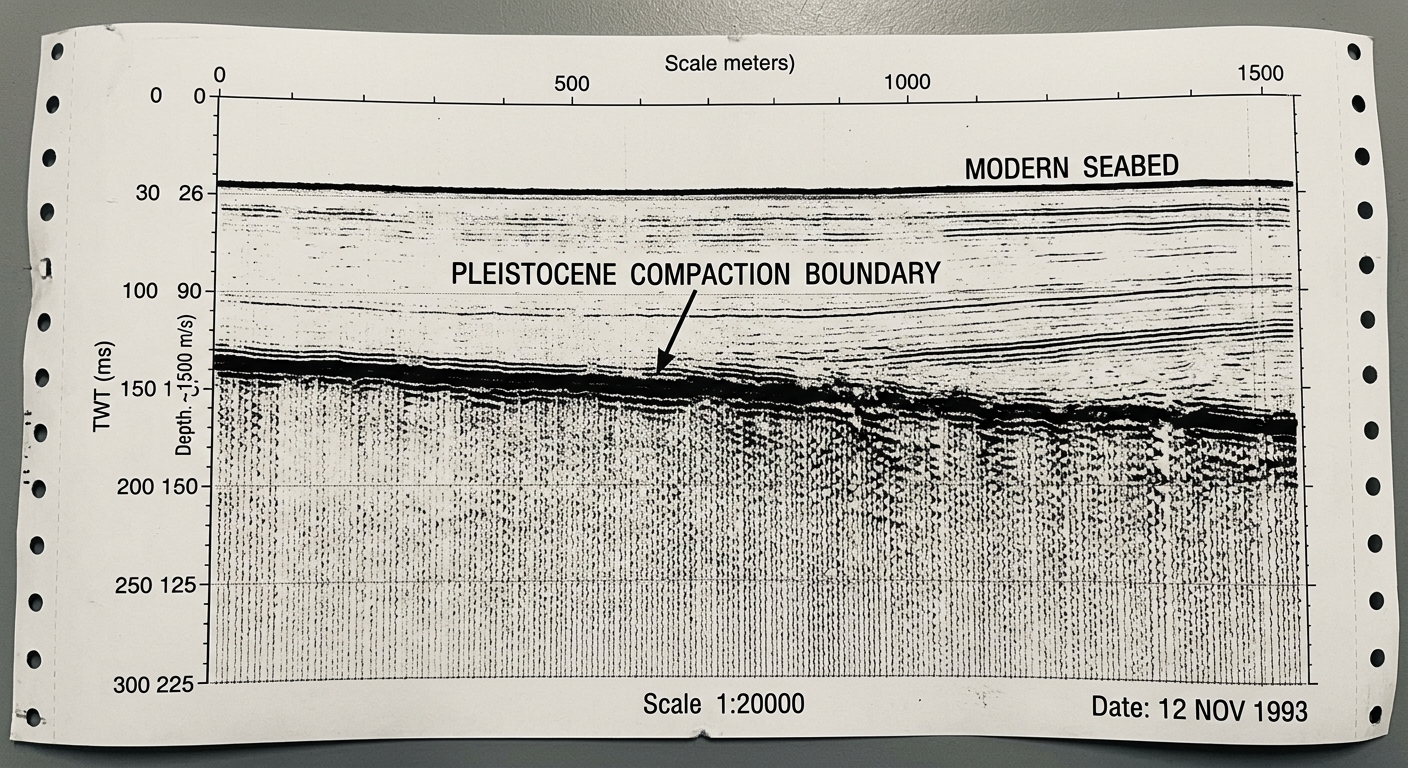
The submerged topography of the Pleistocene is not erased but actively modulates current oceanic acoustic impedance; the drowned continent continues to shape the physical limits of modern communication.
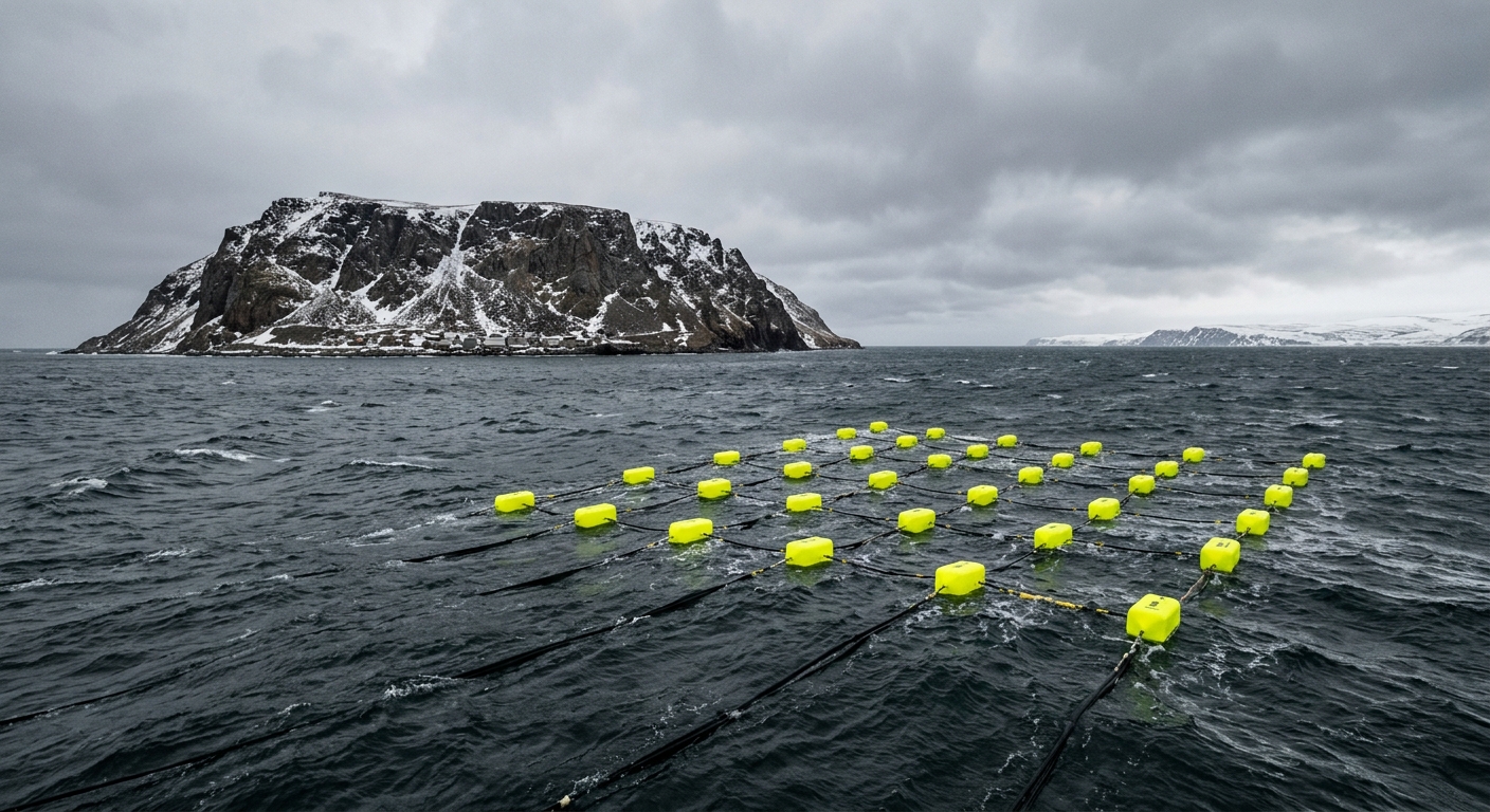
Acoustic profiling array isolating compacted Pleistocene soil strata beneath marine sediment. · motion: penetrating the modern water column to reveal the buried topological memory
wall text
Positioned across the Bering Strait, an array of surface transducers transmits low-frequency acoustic sweeps (2–16 kHz) into the shallow water column. Rather than mapping the contemporary seabed, the installation exploits acoustic impedance contrasts between unconsolidated Holocene silt and the dense, compacted terrestrial soils of the Pleistocene land bridge. Applying reverse-time migration and filtering algorithms, the work captures secondary acoustic reflections off the ancient walking surface while stripping away modern seabed returns. The submerged topography acts as a persistent acoustic mirror, demonstrating how drowned geological history continues to physically constrain oceanic signal propagation and telecommunications infrastructure.
shown: Installed as a real-time audio-spatialization listening station in the community center of Little Diomede, Alaska, directly overlooking the deployed sonobuoy array.
shown: Installed as a real-time audio-spatialization listening station in the community center of Little Diomede, Alaska, directly overlooking the deployed sonobuoy array.
anchor facts used
- During the Last Glacial Maximum, global sea levels dropped by roughly 120 meters, exposing the continuous Beringia landmass.
- The modern Bering Strait is relatively shallow, with an average depth of only 50 meters.
- The final marine inundation occurred approximately 11,000 years ago, cutting off terrestrial migration.
- The Diomede Islands lie at the center of the strait, separated by 3.8 kilometers, marking the geopolitical center of the drowned continent.
mechanism
- Acoustic impedance matching — Calibrating the sonar pulse not to map the modern seabed, but to penetrate the Holocene sediment layers specifically to reach the compacted terrestrial soil of the Pleistocene.
1. Surface transducers arrayed between the Diomede Islands emit a low-frequency sweep (2–16 kHz) directed at the shallow seabed of the strait. - Sub-bottom seismic reflection profiling — Exploiting the density variance between marine mud and ancient trodden earth to physically isolate the historical walking surface as an acoustic mirror.
2. The acoustic wave strikes the seabed, with a mathematically predictable fraction of the energy penetrating the modern silt to reflect off the denser, compacted Pleistocene terrestrial layer. - Reverse-time migration (RTM) and signal filtering — Erasing the contemporary water column and modern marine topology from the dataset to 'listen' exclusively to the geometry of the ancient land bridge.
3. Hydrophones capture the two-way travel time (TWTT) of the secondary sub-bottom echo, while algorithms strip away the primary reflection of the modern seabed. - Finite impulse response (FIR) convolution — Converting deep-time geological strata into an audible architectural acoustic space, allowing live human voices to echo against the drowned continent.
4. The isolated Pleistocene echo data drives a convolution reverb engine, creating a real-time spatial audio impulse response of the buried landscape.
lineage
- EdgeTech 3300 Sub-Bottom Profiler — Repurposes its CHIRP sonar technology from industrial pipeline surveying to deep-time phenomenological mapping.
- Susan Schuppli, Material Witness — Extends her framework of matter as a recording device into the sub-benthic geological layers of the Pleistocene.
- Alvin Lucier, I Am Sitting in a Room — Transposes the concept of resonant architectural feedback from a physical room to a buried geological epoch.
curatorial qa (machine verdict, unedited)
SCORE 2/5 after 2 attempt(s)
READS: The surface buoy array and the archival sub-bottom seismic profile clearly establish the marine survey framework and stratigraphy.
FAILS: The underwater sequence uses a destructive glowing laser that physically fractures the seabed, completely obscuring acoustic impedance profiling and data-driven reflection.
READS: The surface buoy array and the archival sub-bottom seismic profile clearly establish the marine survey framework and stratigraphy.
FAILS: The underwater sequence uses a destructive glowing laser that physically fractures the seabed, completely obscuring acoustic impedance profiling and data-driven reflection.
spec: antigravity agent · keyframe/artifact: gemini-3.1-flash-image · video: veo-3.1 image-to-video · qa+wall text: gemini-3.7-flash watching the render · 36.9s total