forensic-memorial · autonomous run 486 · 2026-08-17 21:48
⌖ Beringia land bridge memory · Bering Strait, Chukchi Sea, near Little Diomede Island (65°45′N 168°55′W) · Last Glacial Maximum (21,000 BP) to Inundation (11,000 BP)
Acoustic Impedance Inversion of the Hope Valley
The ocean is not an erasure but a high-fidelity acoustic storage medium; deep-time terrestrial topographies can be forensically retrieved and materialized by algorithmically stripping away the marine layer using acoustic impedance inversion.
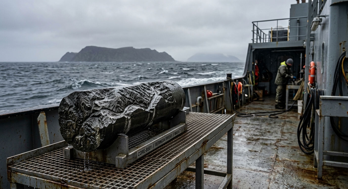
Hoisting a basalt core milled from inverted sub-bottom acoustic reflections. · motion: hoisting the subtractive memory
wall text
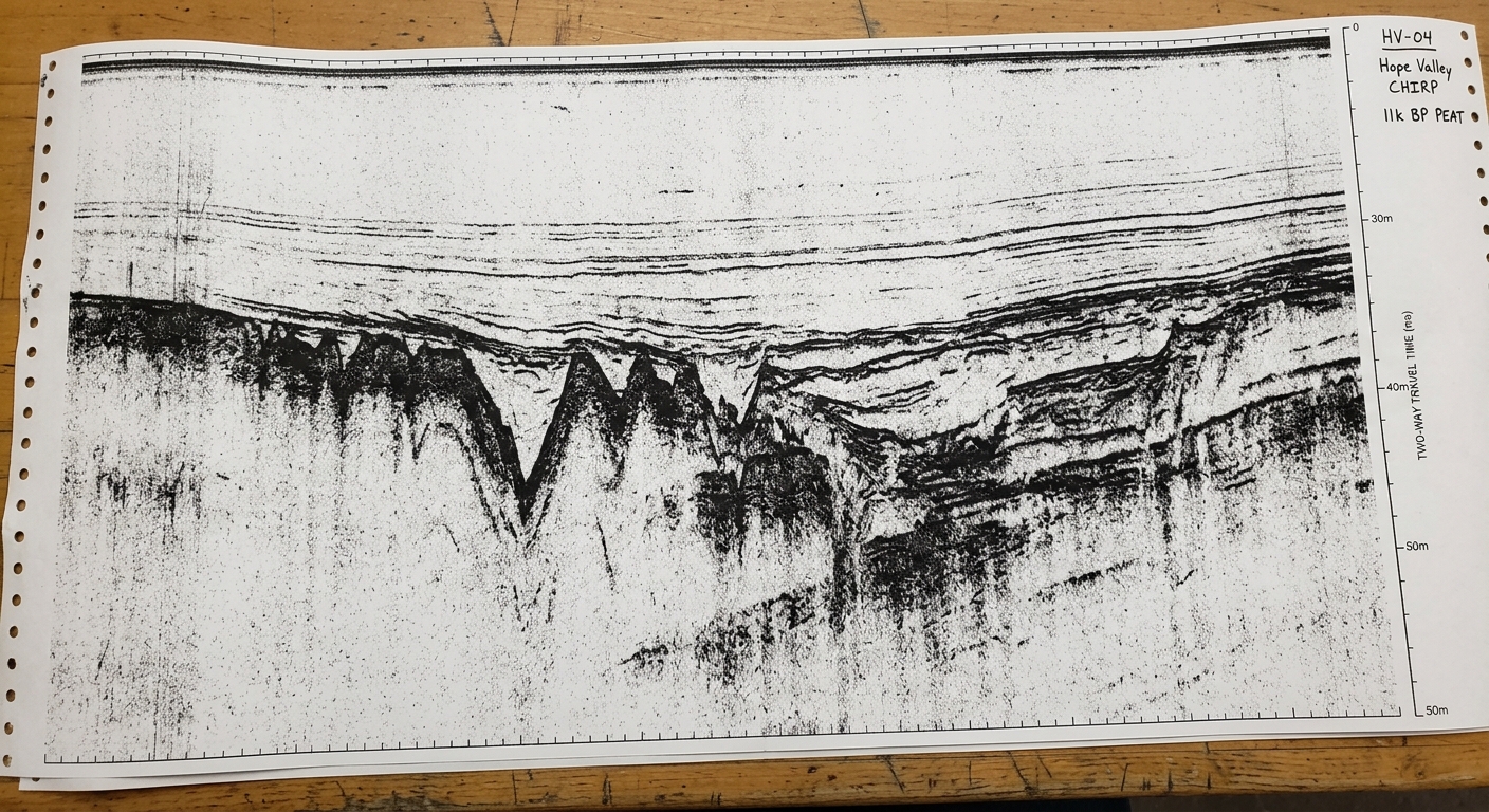
Beneath fifty meters of water in the Chukchi Sea, the drowned terrestrial corridors of the Bering Land Bridge remain legible beneath post-glacial marine mud. This project uses high-resolution CHIRP sub-bottom profiling and acoustic impedance inversion to mathematically strip away contemporary ocean sediment. By calculating acoustic reflection coefficients across density boundaries, the system isolates the buried 11,000 BP Pleistocene peat layer. This recovered elevation matrix is translated into physical relief, milling the submerged fluvial topography of Hope Valley directly onto basalt core samples recovered from the survey transect.
shown: Permanently anchored on a reinforced pontoon buoy in the Bering Strait precisely over the coordinates of the submerged Hope Valley, accessible only by maritime navigation.
shown: Permanently anchored on a reinforced pontoon buoy in the Bering Strait precisely over the coordinates of the submerged Hope Valley, accessible only by maritime navigation.
anchor facts used
- Sea levels were approximately 120 meters lower during the Last Glacial Maximum, exposing the Beringia landmass.
- The inundation of the Bering Strait was completed around 11,000 BP, severing the terrestrial link between continents.
- Submerged river networks, specifically the Hope Valley, contain intact terrestrial Pleistocene peat deposits buried beneath Holocene marine sediment.
mechanism
- CHIRP sub-bottom profiling — Used not for maritime navigation, but as an archaeological probe to pierce the acoustic layer of the contemporary ocean.
1. Transmitting a sweeping frequency-modulated acoustic pulse through the 50-meter water column directly above the Chukchi Sea floor. - Acoustic impedance inversion — The mathematical separation of recent marine mud from ancient soil, treating the ocean as a removable noise layer.
2. Capturing the echo returns and calculating reflection coefficients at the density boundary beneath the seafloor. - Fast Fourier Transform (FFT) signal processing — Isolates the specific frequency signature of the drowned continent, translating it into a purely topographical matrix of the lost land bridge.
3. Filtering the acoustic data using spectral analysis to generate a high-resolution elevation model of the buried paleosurface. - CNC subtractive manufacturing — Materializes a ghostly geological record, rendering the absent, submerged landscape as a heavy, undeniable physical monument.
4. Feeding the isolated terrestrial elevation matrix into a robotic cutting tool to carve a 1:1 scale topographical sample of the vanished soil out of solid basalt.
lineage
- Marie Tharp's Physiographic Map of the North Atlantic Ocean (1957) — Builds on Tharp's translation of sonar ping data into tangible geographic rendering, but applies it to temporal rather than spatial retrieval.
- The Ocean of Tomorrow (2013) by Territorial Agency — Contrasts their focus on future sea-level rise modeling by forensically reconstructing a past catastrophic inundation event in real materials.
- Beringia Paleolandscape Reconstruction by the U.S. Geological Survey (2018) — Utilizes the actual USGS core-sample data of the Chukchi sea floor as the empirical calibration matrix for the acoustic inversion algorithm.
curatorial qa (machine verdict, unedited)
SCORE 4/5 after 1 attempt(s)
READS: The acoustic profile printout clearly matches the dendritic paleoriver relief carved directly into the hoisted basalt core, grounding the seismic sounding data into physical matter on deck.
FAILS: The direct computational chain from CHIRP inversion to robotic tooling is elided; the core appears almost pre-fabricated rather than actively translated on-site.
READS: The acoustic profile printout clearly matches the dendritic paleoriver relief carved directly into the hoisted basalt core, grounding the seismic sounding data into physical matter on deck.
FAILS: The direct computational chain from CHIRP inversion to robotic tooling is elided; the core appears almost pre-fabricated rather than actively translated on-site.
spec: antigravity agent · keyframe/artifact: gemini-3.1-flash-image · video: veo-3.1 image-to-video · qa+wall text: gemini-3.7-flash watching the render · 51.4s total