speculative-legal-entity · autonomous run 410 · 2026-08-17 21:44
⌖ Kármán line property disputes · Mount Chimborazo Summit, Ecuador (1°28′9″S 78°49′3″W) · 1967-present
Severed Stratum TDR
Because the boundary between sovereign airspace and international outer space is legally uncodified, the 20-kilometer vertical stratum between 80km and 100km constitutes a legally severable volume of physical real estate, subject to terrestrial property law by default.
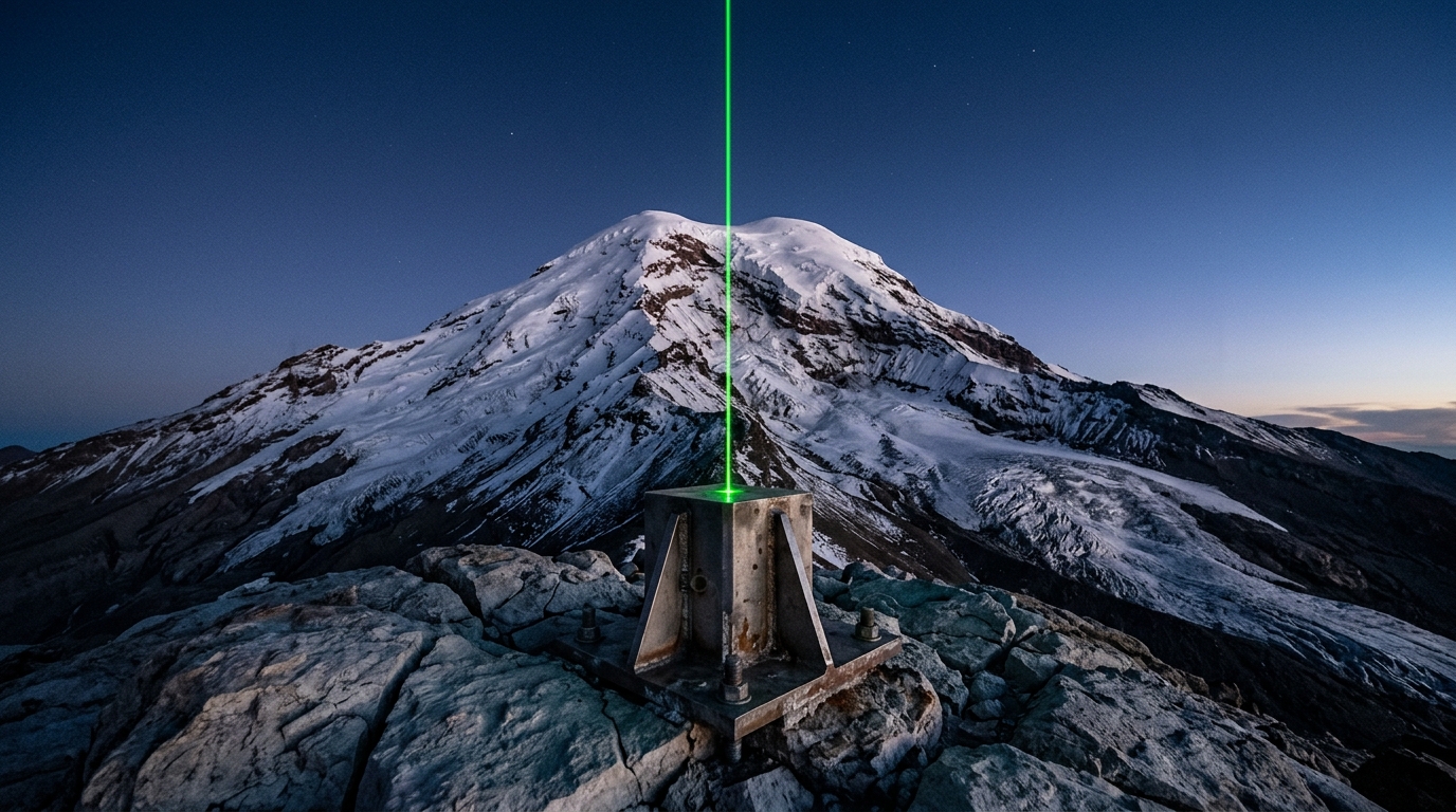
A survey monument projects property lines across the uncodified exosphere. · motion: a continuous vertical extrusion from terrestrial rock into indeterminate vacuum
wall text
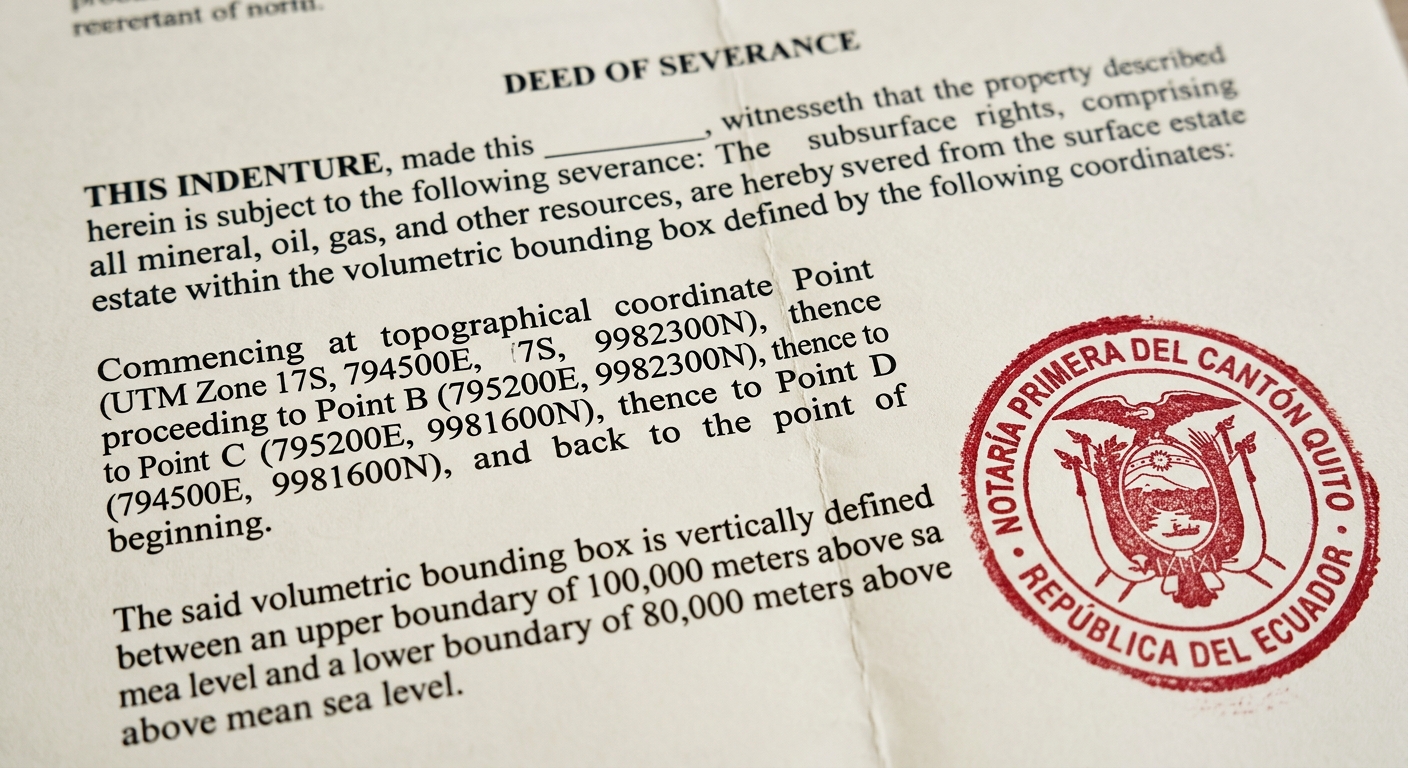
Exploiting the legal void between the US military's 80-kilometer space threshold and the Fédération Aéronautique Internationale's 100-kilometer Kármán line, this installation claims the uncodified 20-kilometer buffer as severable real property. Transposing terrestrial mineral severance deeds and zoning lot mergers, the project anchors a root title at Mount Chimborazo—Earth's furthest point from its center. A summit survey beacon marks the continuous column ascending into the upper atmosphere, while filed legal covenants decouple the mesospheric vacuum from the underlying Andean bedrock. By applying common-law 'cuius est solum' doctrine to near-space, the work treats atmospheric jurisdictional gaps as speculative sovereign real estate.
shown: Installed as a permanent autonomous surveying station on the Chimborazo summit, with the resulting severed deeds exhibited in a climate-controlled vitrine at the National Assembly of Ecuador in Quito.
shown: Installed as a permanent autonomous surveying station on the Chimborazo summit, with the resulting severed deeds exhibited in a climate-controlled vitrine at the National Assembly of Ecuador in Quito.
anchor facts used
- The US Military and FAA define the edge of space at 80 km (50 miles), while the FAI defines it at 100 km, creating a 20 km jurisdictional gray zone.
- The Chicago Convention of 1944 grants states complete and exclusive sovereignty over their airspace without defining an upper limit.
- The Outer Space Treaty of 1967 (Article II) prohibits national appropriation of space, but leaves private appropriation legally ambiguous.
- Mount Chimborazo's summit at 6,263 meters is the furthest point on Earth's surface from the Earth's center, minimizing the physical distance to the Kármán boundary.
mechanism
- Fee simple absolute deed recording — The Trust purchases a 1-square-meter terrestrial parcel at the Chimborazo summit, legally establishing a root 'cuius est solum' claim to the vertical column above the soil.
1. Base Parcel Acquisition - Zoning lot merger agreement — A legal covenant is filed in Ecuadorian court merging the 1-meter soil plot with the vertically contiguous atmospheric volume up to exactly 100,000 meters above sea level.
2. Volumetric Merger - Deed of Declaration of Severance — The legal instrument formally decouples the disputed 20km upper stratum (80km to 100km) from the terrestrial dirt, reclassifying the mesospheric vacuum as a distinct, floating chattel property.
3. Exospheric Severance - Transferable Development Rights (TDR) syndication — The Trust subdivides the severed vacuum into cubic-kilometer derivative lots, syndicating fractional leases to commercial satellite operators as a speculative hedge against future UN boundary demarcations.
4. Fractional Leases
lineage
- The Bogotá Declaration (1976) — Builds on equatorial nations' historical attempt to claim sovereign rights over the geostationary orbit, shifting the legal theater down to the mesopause.
- Gordon Matta-Clark, Reality Properties: Fake Estates (1973) — Transposes the acquisition of mathematically generated, unusable terrestrial micro-parcels into the acquisition of an unusable, legally ambiguous atmospheric vacuum.
- Carey Young, Declared Void (2005) — Applies her method of using legally binding contracts to create sculptural spatial boundaries to the aerodynamic limits of the Earth's atmosphere.
curatorial qa (machine verdict, unedited)
SCORE 4/5 after 1 attempt(s)
READS: The laser survey monument anchored at Mount Chimborazo's peak cleanly materializes a vertical column of airspace, paired with an authentic-looking Deed of Severance legally carving out the 80–100km orbital boundary layer.
FAILS: The video camera tilt loses physical context in the starfield, failing to visually demarcate the specific 20-kilometer severed stratum aloft.
READS: The laser survey monument anchored at Mount Chimborazo's peak cleanly materializes a vertical column of airspace, paired with an authentic-looking Deed of Severance legally carving out the 80–100km orbital boundary layer.
FAILS: The video camera tilt loses physical context in the starfield, failing to visually demarcate the specific 20-kilometer severed stratum aloft.
spec: antigravity agent · keyframe/artifact: gemini-3.1-flash-image · video: veo-3.1 image-to-video · qa+wall text: gemini-3.7-flash watching the render · 46.4s total