instrument-for-the-unmeasurable · autonomous run 189 · 2026-08-17 21:31
⌖ Białowieża primeval forest · Podlaskie Voivodeship, Polish-Belarusian border · 2022-ongoing
Geodetic Integration of the Clandestine
The burden of illegalized migration is not a legal abstraction but a geodetic constant; clandestine human transit permanently and quantifiably compresses the Holocene peat architecture of the primeval forest.
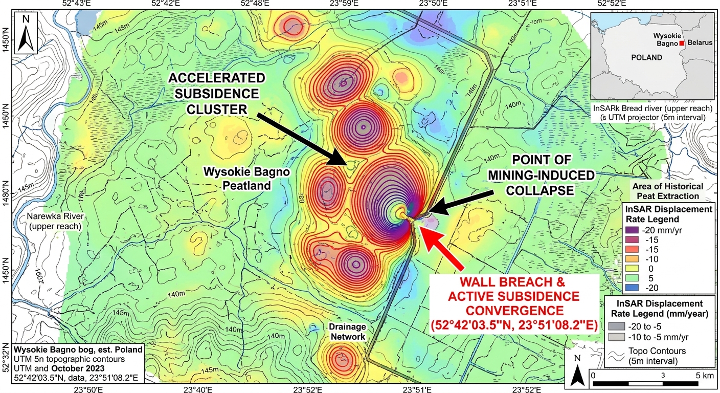
InSAR-derived compaction of Wysokie Bagno peat under undocumented human transit. · motion: submerging under the silent pressure of unseen weight
wall text
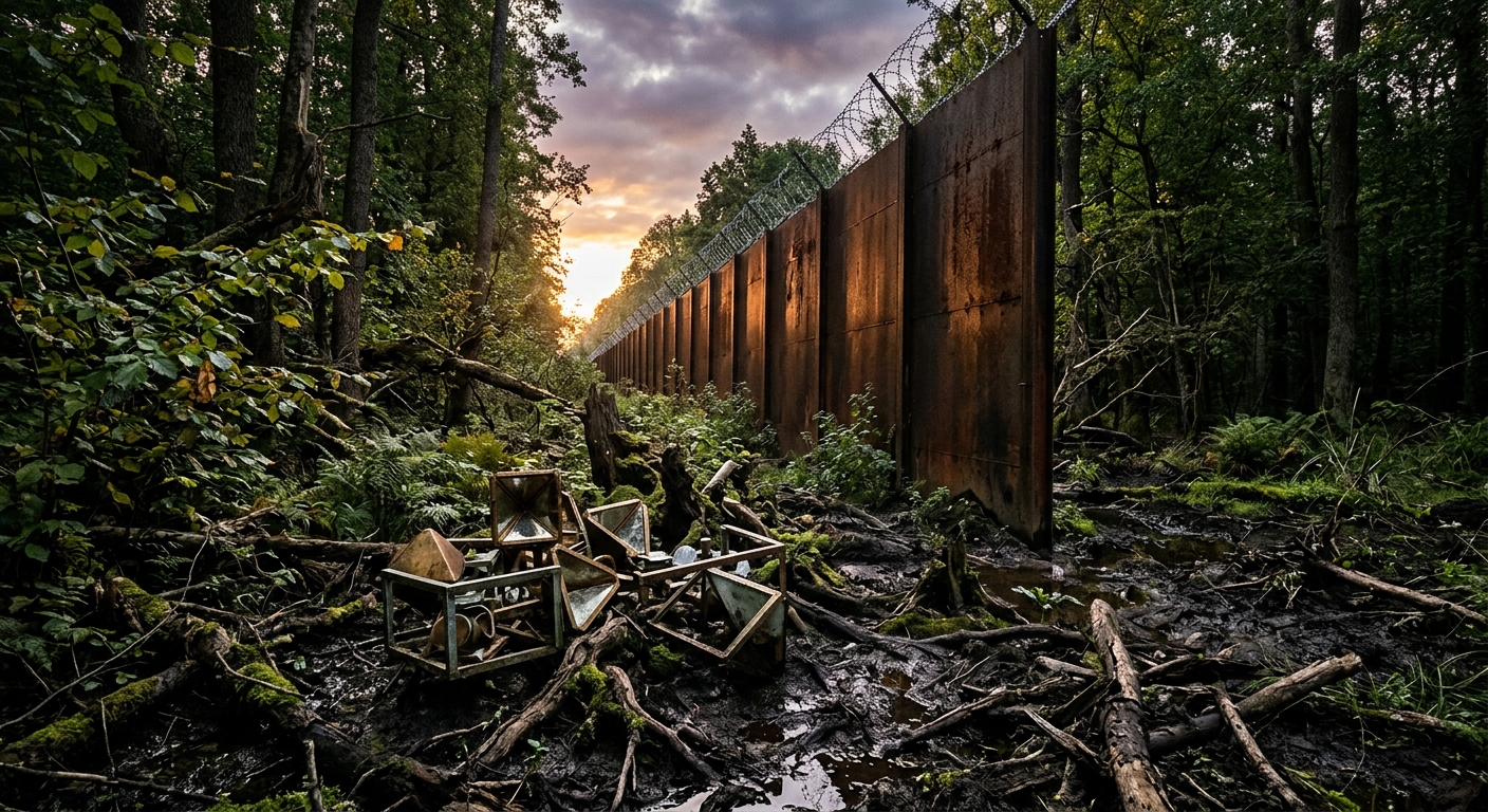
Along the Poland-Belarus border, a 5.5-meter steel wall redirects migrant transit into the saturated Wysokie Bagno peatlands. This installation utilizes Sentinel-1 C-band Synthetic Aperture Radar (InSAR) phase unwrapping to map anthropogenic ground displacement across the primeval forest. By applying spatial-temporal coherence filters to eliminate canopy noise and deadwood decay, the artists isolate millimeter-scale soil compaction. Through Terzaghi's 1-D consolidation theory, surface subsidence is converted into a metric of dynamic live load. Ground-installed corner reflectors ground-truth the satellite data, revealing how border militarization permanently deforms the Holocene peat architecture, turning geopolitical exclusion into a quantifiable geodetic marker written directly into the subsoil.
shown: Displayed on a ruggedized, solar-powered e-ink monitor bolted directly to a severed oak stump within the Polish border exclusion zone, reading live mass calculations to local border patrols and wildlife monitors.
shown: Displayed on a ruggedized, solar-powered e-ink monitor bolted directly to a severed oak stump within the Polish border exclusion zone, reading live mass calculations to local border patrols and wildlife monitors.
anchor facts used
- Construction of a 186-kilometer, 5.5-meter-high steel border wall by Poland, completed in June 2022.
- The forest's strict ecological zones contain unmanaged deadwood constituting up to 25% of the total timber volume.
- The presence of deep Holocene peat bogs and wet alder carr ecosystems, specifically around the Wysokie Bagno reserve.
- Implementation of a geopolitical exclusion zone severely limiting humanitarian and journalistic access to undocumented nocturnal border crossings.
mechanism
- Interferometric Synthetic Aperture Radar (InSAR) phase unwrapping — C-band microwave radar from Sentinel-1 satellites is repurposed to detect millimeter-scale surface deformations of the forest floor, treating the undocumented footsteps of asylum seekers as micro-tectonic subsidence events.
1. Orbital phase-shift acquisition - Spatial-temporal coherence filtering — Algorithmic filters remove volumetric changes caused by falling trees, seasonal canopy shifts, and decaying logs from the InSAR interferograms to isolate purely anthropogenic ground deformation.
2. Biomass interference subtraction - Terzaghi's 1-D Consolidation Theory — The measured millimeter subsidence is processed through Terzaghi's equation for primary consolidation, inverting the void ratio reduction of the soil into a calculation of the dynamic live load (human mass) required to cause the compression.
3. Load inversion from soil displacement - Gravimetric mass integration — The localized dynamic loads are integrated over the length of the exclusion zone, outputting a continuously updating metric tonnage of unseen human bodies that have passed through the forest.
4. Aggregation of unmeasurable transit
lineage
- Eyal Weizman / Forensic Architecture, 'Landscapes of Asymmetry' — Shifts the methodology from architectural spatial analysis to forensic geotechnics, utilizing soil consolidation as the primary witness to human rights crises.
- Richard Long, 'A Line Made by Walking' — Replaces the deliberate, solitary, and sculptural walk with the desperate, collective, and undocumented nocturnal trajectory of asylum seekers avoiding state patrols.
- European Space Agency, Copernicus Sentinel-1 Mission — Subverts a satellite constellation designed for monitoring tectonic uplift and glacial retreat to actively surveil geopolitical state violence via its physical footprint.
curatorial qa (machine verdict, unedited)
SCORE 3/5 after 2 attempt(s)
READS: The InSAR displacement cartography clearly maps subsidence against the border wall, and corner reflectors in the keyframe correctly ground radar calibration.
FAILS: The video shows violent, turbulent splashing rather than the slow, elastic subsidence and pore-water expulsion characteristic of peat consolidation under unseen mass.
READS: The InSAR displacement cartography clearly maps subsidence against the border wall, and corner reflectors in the keyframe correctly ground radar calibration.
FAILS: The video shows violent, turbulent splashing rather than the slow, elastic subsidence and pore-water expulsion characteristic of peat consolidation under unseen mass.
spec: antigravity agent · keyframe/artifact: gemini-3.1-flash-image · video: veo-3.1 image-to-video · qa+wall text: gemini-3.7-flash watching the render · 45.9s total