literalize-the-metaphor · autonomous run 161 · 2026-08-17 21:29
⌖ Kármán line property disputes · Quito, Ecuador (0°13'0"S 78°31'0"W) · 1976-Present
Bogota Toll: 100km Boundary Enforcement
Sovereignty is not an inherent geographic truth, but a function of the sensory resolution and automated enforcement mechanisms deployed to police its borders.
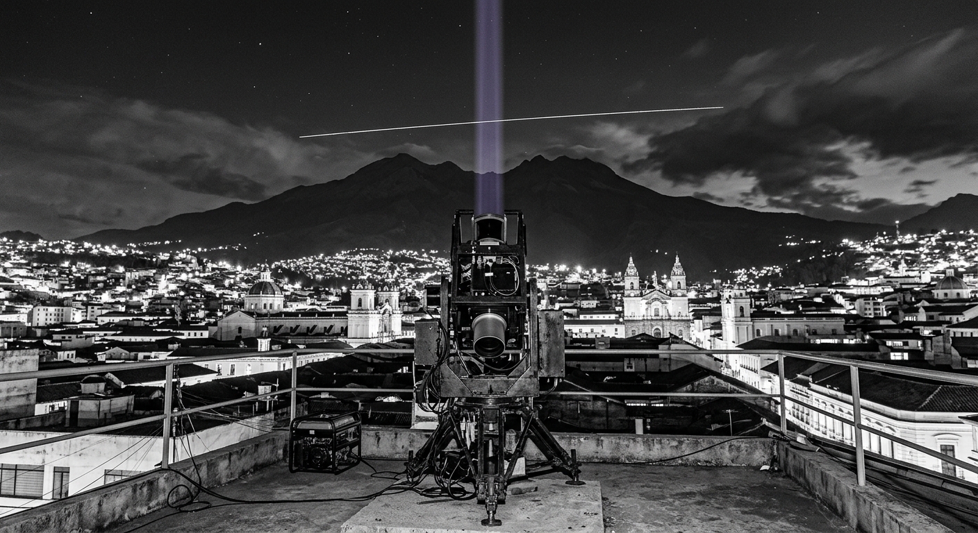
Equatorial zenith LiDAR logging billable satellite crossings at the Kármán line. · motion: scanning the zenith with mechanical indifference to celestial beauty
wall text
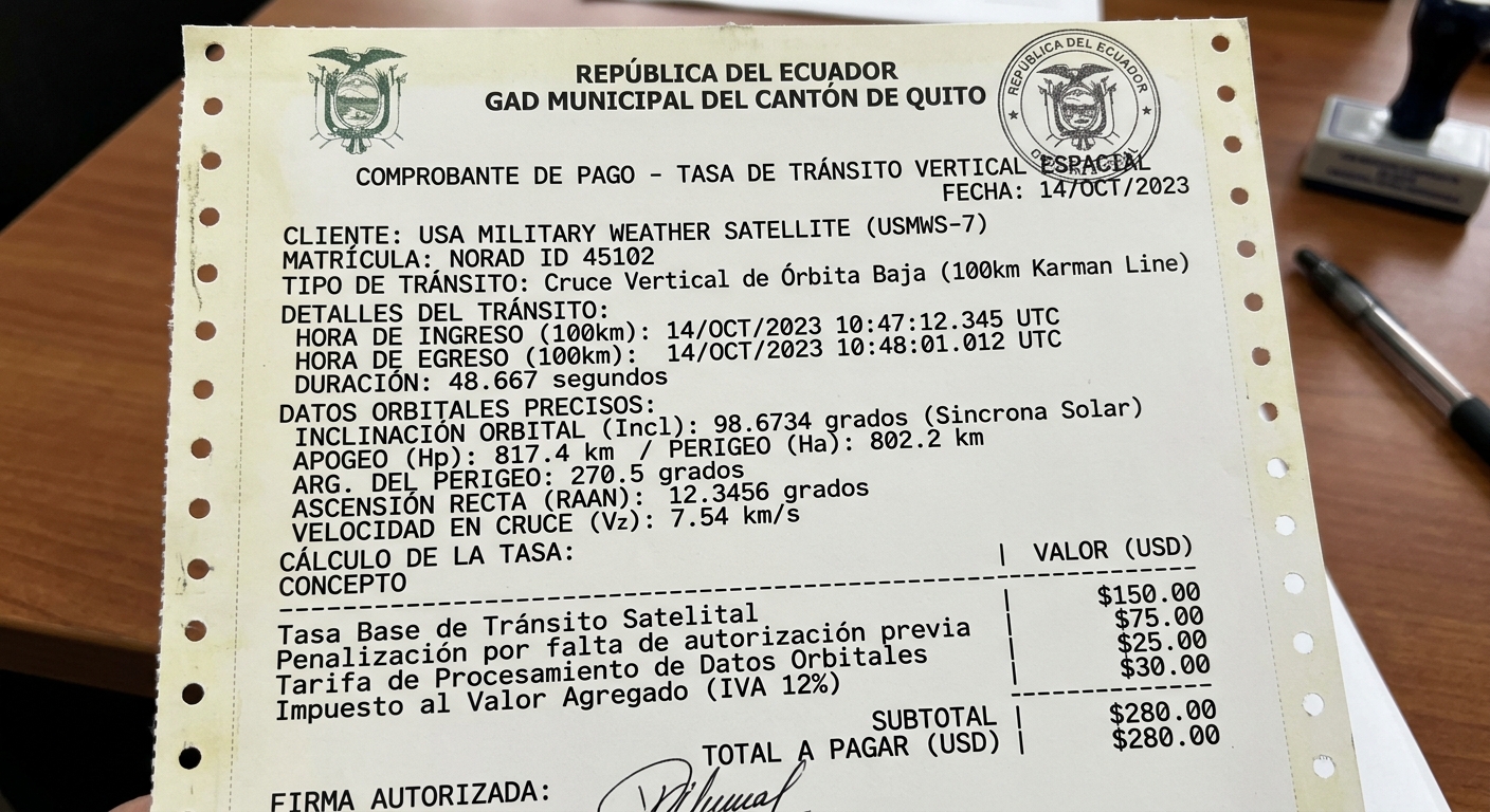
Positioned in Quito, a ground-based continuous-wave Doppler LiDAR fires directly at the zenith, monitoring the vertical atmospheric column between 99 and 101 kilometers. By treating the Kármán line as an enforceable sovereign boundary rather than an abstract legal convention, the installation repurposes atmospheric aerosol surveying into an automated municipal speed trap. When low-Earth-orbit objects cross this equatorial corridor, their orbital trajectories, velocity vectors, and radar cross-sections are matched against NORAD orbital registries. The system calculates vertical transit fees and prints automated fines on dot-matrix municipal vouchers, turning orbital dynamics into routine jurisdictional revenue extraction.
shown: Installed permanently on the roof of the Yaku Water Museum in Quito, Ecuador, directly beneath the equatorial orbital plane, operating continuously and displaying real-time invoices on an LED ticker.
shown: Installed permanently on the roof of the Yaku Water Museum in Quito, Ecuador, directly beneath the equatorial orbital plane, operating continuously and displaying real-time invoices on an LED ticker.
anchor facts used
- The 1976 Bogota Declaration, where eight equatorial nations formally claimed sovereignty over the geostationary orbits directly above their territories.
- The Fédération Aéronautique Internationale (FAI) definition of the Kármán line at exactly 100 km above mean sea level, marking the end of aeronautics and the beginning of astronautics.
- The 1967 Outer Space Treaty, Article II, which explicitly prohibits national appropriation of outer space, creating an unresolved legal paradox with the Bogota Declaration.
mechanism
- Continuous-wave Doppler LiDAR atmospheric scanning — Repurposed from meteorological aerosol surveying to function as a strictly defined legal boundary tripwire at the edge of the atmosphere.
1. A continuous-wave LiDAR array at 0°13'0"S 78°31'0"W points directly at the zenith, actively scanning the 99km to 101km vertical corridor. - Automated traffic enforcement (speed camera) triggering logic — Scaling the mechanism of a terrestrial highway speed trap to capture suborbital and low-Earth-orbit velocities.
2. When an ascending, descending, or orbiting object crosses the exact 100.000 km threshold overhead, the system records its velocity, exact altitude, and radar cross-section. - NORAD Two-Line Element (TLE) set propagation and database correlation — Using international orbital mechanics tracking data as the functional equivalent of an automated vehicle license plate registry.
3. The system dynamically cross-references the object's recorded trajectory against the UNOOSA Register to identify the sovereign owner. - Electronic Toll Collection (ETC) invoicing via Automated Clearing House (ACH) — Applying municipal highway tolling and fee extraction logic to internationally contested orbital boundaries.
4. An automated contract generates a legally formatted invoice for 'unauthorized vertical transit', routing the fee demand directly to the offending state's treasury.
lineage
- Eyal Weizman, 'Forensic Architecture: Violence at the Threshold of Detectability' — Extends Weizman's spatial analysis of vertical sovereignty from Palestinian airspace into low Earth orbit.
- Trevor Paglen, 'The Last Pictures' — Pivots from Paglen's poetic, passive documentation of orbital artifacts to an active legal and financial interference mechanism.
- James Bridle, 'Autonomous Trap 001' — Scales the entrapment of automated systems from terrestrial self-driving cars to international space law and satellite telemetry.
curatorial qa (machine verdict, unedited)
SCORE 4/5 after 1 attempt(s)
READS: The vertical LiDAR tripwire intersects orbital paths above Quito, directly pairing with the dot-matrix municipal toll receipt issued to a passing military satellite.
FAILS: The beam remains static rather than showing active pulse-ranging or real-time triggering telemetry as the satellite streak passes.
READS: The vertical LiDAR tripwire intersects orbital paths above Quito, directly pairing with the dot-matrix municipal toll receipt issued to a passing military satellite.
FAILS: The beam remains static rather than showing active pulse-ranging or real-time triggering telemetry as the satellite streak passes.
spec: antigravity agent · keyframe/artifact: gemini-3.1-flash-image · video: veo-3.1 image-to-video · qa+wall text: gemini-3.7-flash watching the render · 47.1s total