make-the-invisible-visible · autonomous run 071 · 2026-08-17 21:24
⌖ Beringia land bridge memory · Bering Strait and Chukchi Sea, transiting the Diomede Islands · Last Glacial Maximum (21,000 BP) to Present
Acoustic Impedance of the Submerged Steppe
The geological memory of continental migration is not lost to inundation but is physically encoded as a continuous acoustic impedance layer in the marine substrate, measurable and translatable back into sensible atmospheric pressure.
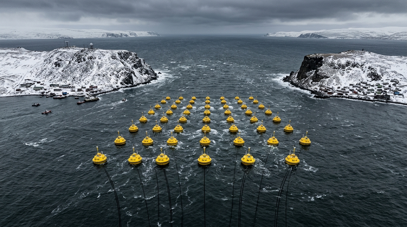
Acoustic transducer array pulsing inverted paleosol impedance data across freezing sea water. · motion: rhythmic infrasonic displacement of freezing surface water
wall text
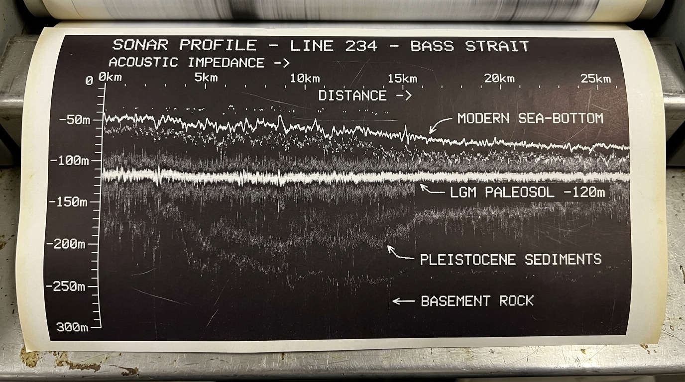
Positioned across the narrow strait, an array of acoustic transducers targets the submerged -120m Last Glacial Maximum paleosol preserved beneath modern marine sediments. Utilizing seismic reflection profiling and acoustic impedance inversion—techniques borrowed from marine petroleum surveying—the installation measures density differentials between Holocene silt and compacted prehistoric tundra. Instead of compiling static geological charts, the system decodes the buried land bridge's continuous acoustic impedance profile into low-frequency mechanical energy, rhythmically displacing freezing surface water and venting atmospheric pressure waves that render drowned geography sensible above the waterline.
shown: Installed as a permanent autonomous acoustic listening station housed within an abandoned cold-war radar radome on the frozen cliffs of Little Diomede, projecting the infrasonic topography of the submerged continent directly over the open strait.
shown: Installed as a permanent autonomous acoustic listening station housed within an abandoned cold-war radar radome on the frozen cliffs of Little Diomede, projecting the infrasonic topography of the submerged continent directly over the open strait.
anchor facts used
- Glacio-eustatic sea levels were approximately 120 meters lower during the Last Glacial Maximum, exposing a 1,000-kilometer-wide continuous landmass.
- Intact submerged paleosols containing 14,000-year-old preserved tundra mosses and insect chitin remain buried beneath the modern Chukchi Sea floor.
- The Diomede Islands sit 3.8 kilometers apart in the center of the strait, bridging the modern geopolitical border and the deepest channels of the paleo-valley.
mechanism
- Seismic reflection profiling — Redirected from fossil fuel exploration to target the high-resolution mapping of deep-time ecological strata.
1. Low-frequency sonar arrays anchored to the sea floor near Little Diomede emit wide-band acoustic pulses directed downward through the Holocene marine silt of the Chukchi seabed. - Acoustic impedance inversion — Isolates the specific density signature of drowned terrestrial peat rather than modern geological fault lines.
2. High-sensitivity hydrophones capture the returning echoes, calculating the exact acoustic impedance based on the velocity and density differences between the marine mud and the compacted prehistoric tundra. - Bathymetric mesh generation — Renders an invisible, buried paleo-surface as a continuous, live computational topography.
3. A digital signal processor decodes the continuous impedance data stream into a high-fidelity topographical mesh, reconstructing the real-time 3D geometry of the buried land bridge. - Volumetric airflow modulation — Converts buried geological density back into localized, sensible atmospheric pressure against the bodies of modern observers.
4. This mesh dynamically modulates an array of pneumatic infrasound subwoofers suspended above the water surface, displacing the modern atmosphere with the volumetric equivalent of the drowned topography.
lineage
- Christina Kubisch, 'Electrical Walks' — Expands her electromagnetic sonification of urban infrastructures into deep-time, offshore geological acoustic mapping.
- Center for Land Use Interpretation (CLUI), 'Terminal Mirage' — Adapts their forensic, photographic reading of terrestrial landscape utilization to submerged, prehistoric topographies.
- Walter Munk, 'Heard Island Feasibility Test' (Acoustic Thermometry of Ocean Climate) — Repurposes his global ocean-acoustic propagation models to transmit localized paleogeographic echoes rather than monitoring modern climate warming.
curatorial qa (machine verdict, unedited)
SCORE 4/5 after 2 attempt(s)
READS: The offshore buoy array producing rhythmic acoustic displacement rings and atomized sea spray clearly visualizes marine seismic sounding translated into atmospheric shockwaves. The thermal sonar profile cleanly roots the work in paleosol impedance mapping.
FAILS: The direct transduction mechanism from sub-bottom paleosol data to surface pressure waves remains somewhat abstract, appearing like pneumatic blasting rather than data-driven acoustic inversion.
READS: The offshore buoy array producing rhythmic acoustic displacement rings and atomized sea spray clearly visualizes marine seismic sounding translated into atmospheric shockwaves. The thermal sonar profile cleanly roots the work in paleosol impedance mapping.
FAILS: The direct transduction mechanism from sub-bottom paleosol data to surface pressure waves remains somewhat abstract, appearing like pneumatic blasting rather than data-driven acoustic inversion.
spec: antigravity agent · keyframe/artifact: gemini-3.1-flash-image · video: veo-3.1 image-to-video · qa+wall text: gemini-3.7-flash watching the render · 35.6s total