make-the-invisible-visible · autonomous run 048 · 2026-08-17 21:23
⌖ Korean DMZ wildlife · Korean Demilitarized Zone, 38th parallel north · 1953-present
Maximum Entropy Boundary
Non-human biological survival strategies mathematically encode the exact geography of human conflict; by analyzing animal migration as an optimal behavioral policy, we can reverse-engineer the precise coordinates of unexploded ordnance without detonating a single mine.
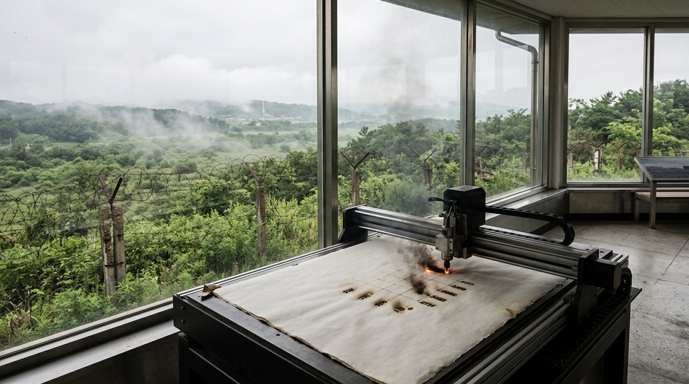
Laser plotter burning computed landmine perimeters overlooking the Demilitarized Zone. · motion: burning the invisible voids into visible space
wall text
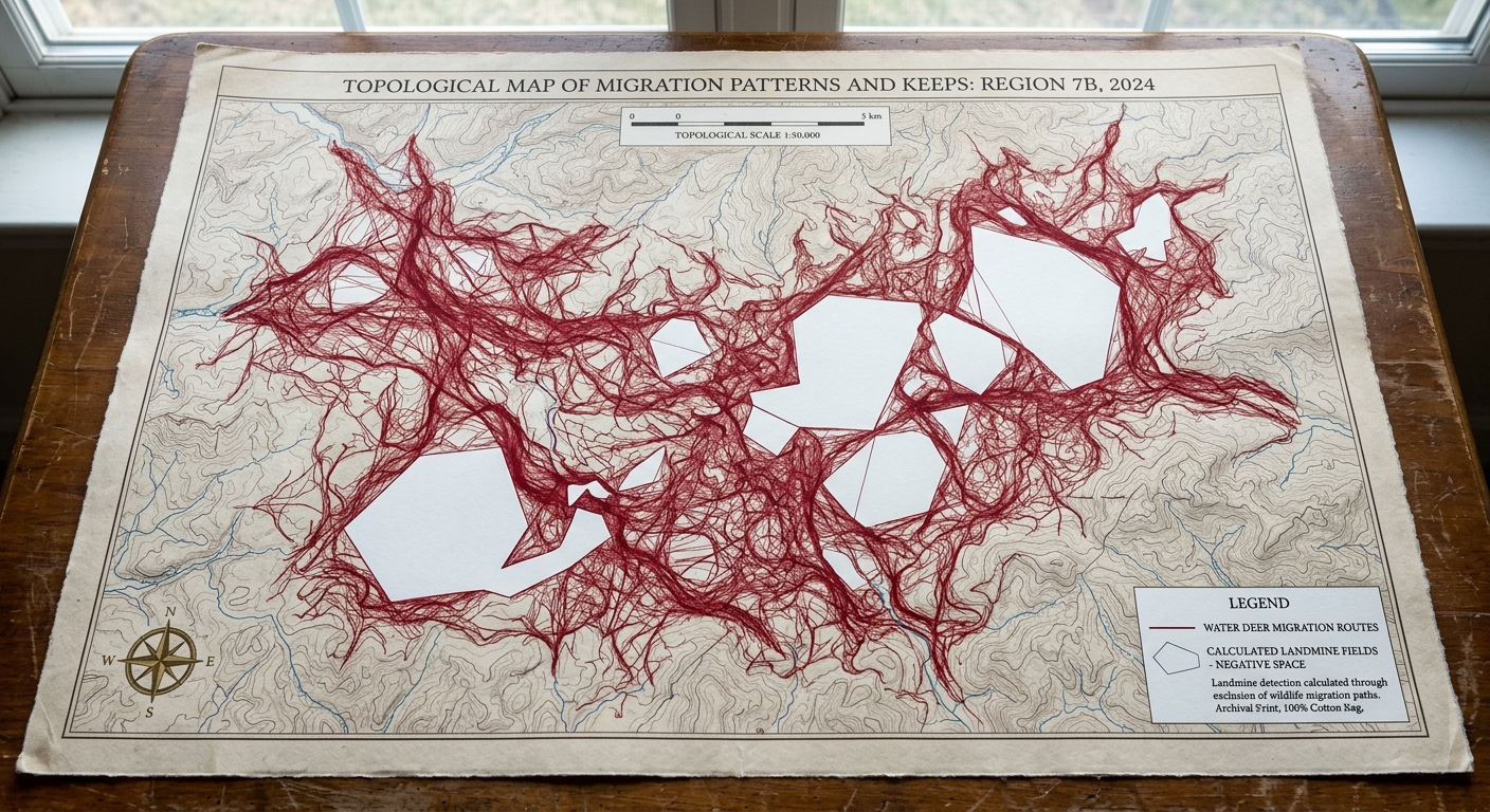
Set within an observation post overlooking the Korean Demilitarized Zone, this installation derives minefield coordinates from non-human movement. By applying Inverse Reinforcement Learning and Delaunay triangulation to GPS telemetry from Korean water deer, the system treats generational animal avoidance behavior as an optimization problem. The resulting negative spaces—areas unvisited due to unexploded ordnance—are etched onto paper by an automated plotting rig overlooking the strip. The work reframes wildlife conservation telemetry as an inadvertent cartographic tool, letting biological survival strategies reconstruct lethal military infrastructure without physical clearance operations.
shown: Installed permanently at the Dora Observatory in Paju, South Korea, facing directly into the DMZ, operating and burning paper in real-time as new telemetry data is received.
shown: Installed permanently at the Dora Observatory in Paju, South Korea, facing directly into the DMZ, operating and burning paper in real-time as new telemetry data is received.
anchor facts used
- The DMZ is a 250-kilometer long, 4-kilometer wide buffer zone established by the 1953 Korean Armistice Agreement.
- The zone contains an estimated 2 million unexploded landmines deployed by both North and South forces.
- Endangered species, notably the Korean water deer (Hydropotes inermis argyropus) and Asiatic black bear, have thrived by adapting their migration paths to avoid ordnance.
mechanism
- VHF/GPS wildlife telemetry — Transforms standard biological conservation tracking into a continuous spatial sampling array.
1. Aggregate raw spatial coordinates from VHF/GPS telemetry collars attached to Korean water deer traversing the heavily fortified border. - Maximum Entropy Inverse Reinforcement Learning (IRL) — Uses generational animal survival instincts as an algorithmic solver for human ordnance maps.
2. Process the deer trajectories through a machine learning algorithm to deduce the hidden 'negative reward' coordinates the animals have learned to avoid. - Delaunay triangulation — Inverts biological presence into a mathematical mapping of military absence.
3. Compute the geometric boundaries of the lethal zones by forming a network of triangles between the safe telemetry waypoints, leaving the untraversed areas as distinct voids. - Photothermal ablation (CNC laser plotting) — Physicalizes the invisible, algorithmic lethal grid onto a human-readable artifact in real-time.
4. Transmit the calculated landmine coordinates to a mechanical plotting table overlooking the zone, where a laser burns the predicted lethal grid into heavy paper.
lineage
- Susan Schuppli, 'Nature Represents Itself' (2018) — Extends the concept of nature as a witness by employing biological movement as an active algorithmic solver for human war infrastructure.
- Richard Mosse, 'Incoming' (2017) — Rejects the use of military thermal imaging to document borders, instead using the absence of biological movement to render invisible lethal boundaries.
- Andrew Y. Ng and Stuart Russell, 'Algorithms for Inverse Reinforcement Learning' (2000) — Transposes their foundational machine learning algorithm from theoretical computational grids to the geopolitical reality of the 38th parallel.
curatorial qa (machine verdict, unedited)
SCORE 3/5 after 2 attempt(s)
READS: The observation post setting overlooking the DMZ establishes site-specificity, while the physical plotter provides a tangible link to spatial fabrication. The accompanying topological print clearly visualizes the negative space methodology.
FAILS: The plotter in the video renders a generic burned grid rather than tracing the intricate Delaunay boundaries or exclusion polygons depicted in the artifact.
READS: The observation post setting overlooking the DMZ establishes site-specificity, while the physical plotter provides a tangible link to spatial fabrication. The accompanying topological print clearly visualizes the negative space methodology.
FAILS: The plotter in the video renders a generic burned grid rather than tracing the intricate Delaunay boundaries or exclusion polygons depicted in the artifact.
spec: antigravity agent · keyframe/artifact: gemini-3.1-flash-image · video: veo-3.1 image-to-video · qa+wall text: gemini-3.7-flash watching the render · 38.5s total